- Bandar Aman Jaya
- Seri perigi
- Lembah Bujang
- Singkir Laut
- Tanjung Jaga
- Pedu Dam
- Bukit Larek
- Bukit Kelubi
- Bukit Jabi
- Bukit Kechil
- Guar Geteri
- Guar Jentik
- Gua Kelam
- Kuari Kang Giap
- Utan Aji
- Pondok Nibong
- Pasir Tengkorak
- Pantai Pasir Hitam
- Durian Perangin
- Tanjung Mali
- Penarak
Showing posts with label Geological Fieldtrip. Show all posts
Showing posts with label Geological Fieldtrip. Show all posts
Wednesday, June 12, 2019
Fieldtrip:Malaysia_West Coast
During this Fieldtrip we visited following locality:

Tuesday, July 17, 2018
Fieldtrip: Vietnam_Hanoi
Objective of this Fieldtrip is to characterize the fractures observed onshore as analogue for offshore Exploration. Producing field from Basement include the famous Bach Ho Field whick flowed oil from fractured granite.
Fieldtrip area located around the famous Red River Fault in Hanoi, Vietnam. Map by Cullen below shows other main tectonic element in Southeast Asia.

Vietnam can be divided into 5 Structural blocks.The visited area consist of Northeast Block and Northwest Block

The Onshore Geological Map of Hanoi area can be observed below:

Total of 14 Locality visited during this trip. The path followed is shown below.

The younger outcrop located mostly in the Northern part and gets older in the south

Location of the Locality visited each day is marked in maps below:


Some of the rock samples in the outcrop can be seen below:

The diagram below shows the different classification of Fracture type (From AAPG Method 10). The outcrop pictures is showing the Character of fractures in different type of Lithology-Limestone, Gneiss and Granite.

Friday, February 9, 2018
Fieldtrip: Malaysia_Bahau
This is our first fieldtrip for UKM Student. It is 2 day trip where we travel by bus and stay overnight at Bahau town.
There are total 9 Localities visited during this fieldtrip.


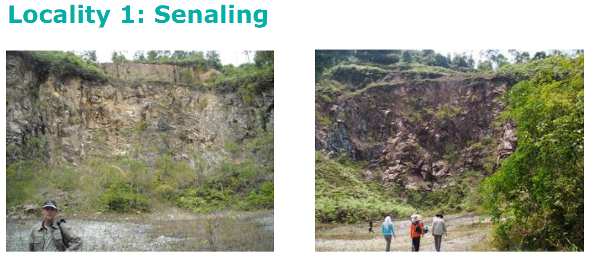
1. Senaling

2. Jalan Dangi langkap
No Record
3. Jalan Felda Bukit Rokan

•Dark Grey carbonaceous quartz-chlorite-mica schist, characterized by crenulation or kink folds
4. Felda Bukit Rokan Barat Housing

5.Jalan Kepis-Rompin

6.Bukit Jeram Padang

NW trending Bukit Jeram Padang Ridge consist of mainly sandstone and shale of Middle Triassic. Fossil of Bivalve, gastropod and arthropod preserved as mould and cast.
7. Km6 Gemas-Tampin
No Record
8. Yam Fong Quarry, Segamat

Segamat Basalt, together with Kuantan Basalt occur on the southern periphery of a great geographical field of rift related alkaline basalts that extend up to Hainan Island (Hutchinson,1989). K-Ar minimum age of these rock as reported by Bignell & Snelling (1997) is 62 Ma
The basalt that we visited is in an abandoned quarry.
The quarry now filled with water.

9. Ophir Quarry, Johor

an old photo of me & friends

I would like to thank my junior's for properly documenting their fieldtip. I had used the pictures and materials from their blog because i lack documenting awareness back then.
http://geomaira90.blogspot.com/2009/11/#.W1RfK9UzaUk
https://cheekylulu.wordpress.com/2008/10/27/
There are total 9 Localities visited during this fieldtrip.


1. Senaling
2. Jalan Dangi langkap
No Record
3. Jalan Felda Bukit Rokan

•Dark Grey carbonaceous quartz-chlorite-mica schist, characterized by crenulation or kink folds
•Strikes
NNW
•Lower
Carboniferous radiolaria
4. Felda Bukit Rokan Barat Housing

Serpentinite is usually strongly sheared,
yellow and green colored and composed of antigorite and chrysolite

6.Bukit Jeram Padang

NW trending Bukit Jeram Padang Ridge consist of mainly sandstone and shale of Middle Triassic. Fossil of Bivalve, gastropod and arthropod preserved as mould and cast.
7. Km6 Gemas-Tampin
No Record
8. Yam Fong Quarry, Segamat

Segamat Basalt, together with Kuantan Basalt occur on the southern periphery of a great geographical field of rift related alkaline basalts that extend up to Hainan Island (Hutchinson,1989). K-Ar minimum age of these rock as reported by Bignell & Snelling (1997) is 62 Ma
The basalt that we visited is in an abandoned quarry.
The quarry now filled with water.

9. Ophir Quarry, Johor

an old photo of me & friends

I would like to thank my junior's for properly documenting their fieldtip. I had used the pictures and materials from their blog because i lack documenting awareness back then.
http://geomaira90.blogspot.com/2009/11/#.W1RfK9UzaUk
https://cheekylulu.wordpress.com/2008/10/27/
Geological Fieldtrip
One of my favorite activity as a geologist is going for field trip.
Listed below are some of the Field trip that i've joined throughout the years and will be shared in this Blog:
Listed below are some of the Field trip that i've joined throughout the years and will be shared in this Blog:
- Bahau and Segamat (1st year UKM)
- Pantai Timur Semenanjung (1st Year UKM)
- Taman Pantun UKM
- Port Dickson
- Sungai Tekala, Hulu Langat
- Pantai Barat Semenanjung (2nd Year UKM)
- Bukit Keluang (2nd Year UKM)
- Kuala Krai (2nd Year UKM)
- Miri, Sarawak
- Morib and Jugra, Selangor
- Jalur Tengah Semenanjung
- Sicily, Italy
- Ythan, Scotland
- Utah, USA
- Stonehaven, Scotland
- Pekan, Pahang
- Labuan, Malaysia
- Kota Kinabalu, Sabah
- Pulau Seribu and Bandung, Indonesia
- Mahakam Delta, Kalimantan
- Hanoi, Vietnam (2017)
Beside actual fieldtrip, since Covid-19 Pandemic, Virtual Outcrop had become an alternative, especially due to some other plus point such as:
- Can visit multiple places in one session
- Access difficult and dangerous sections-cliff
- Politically and logistically challenging locations
- Outcrops that no longer exist
- Supplement existing fieldtrip with pre and post session
- for mobility restricted students and researchers
- cost saving
Sunday, January 21, 2018
Geological Fieldtrip Tools
1. Compass
I believe this is one of the most important tool. The Suunto MC-2 model that i had was bought back in my first year in 2007. Besides compass, it had inclination measurement, ruler and lens.

2. Measuring Tape
I bought this during Fieldtrip Class in university where we learn field mapping subject in that semester.

3.Ruler
I got this FOC during company field trip that i followed. Useful for scale when taking pictures at outcrop.

4. DSLR Camera
The model that i had is Canon EOS 550 model. I like DSLR because its easy to use, sturdy and give good quality photo.

5. GPS
I bought this originally for tourism purposes. But i found it very useful to locate my exact location in the field. When i'm back from field trip i would plot the location in Google Earth.

6. Binocular
I bought this Vanguard model during my Msc time. Handy for looking distant outcrop.

6. Grain Size Comparator
Usually obtained free from service company. But i've lost most of it.
I believe this is one of the most important tool. The Suunto MC-2 model that i had was bought back in my first year in 2007. Besides compass, it had inclination measurement, ruler and lens.

2. Measuring Tape
I bought this during Fieldtrip Class in university where we learn field mapping subject in that semester.

3.Ruler
I got this FOC during company field trip that i followed. Useful for scale when taking pictures at outcrop.

4. DSLR Camera
The model that i had is Canon EOS 550 model. I like DSLR because its easy to use, sturdy and give good quality photo.

5. GPS
I bought this originally for tourism purposes. But i found it very useful to locate my exact location in the field. When i'm back from field trip i would plot the location in Google Earth.

6. Binocular
I bought this Vanguard model during my Msc time. Handy for looking distant outcrop.

6. Grain Size Comparator
Usually obtained free from service company. But i've lost most of it.
Subscribe to:
Posts (Atom)